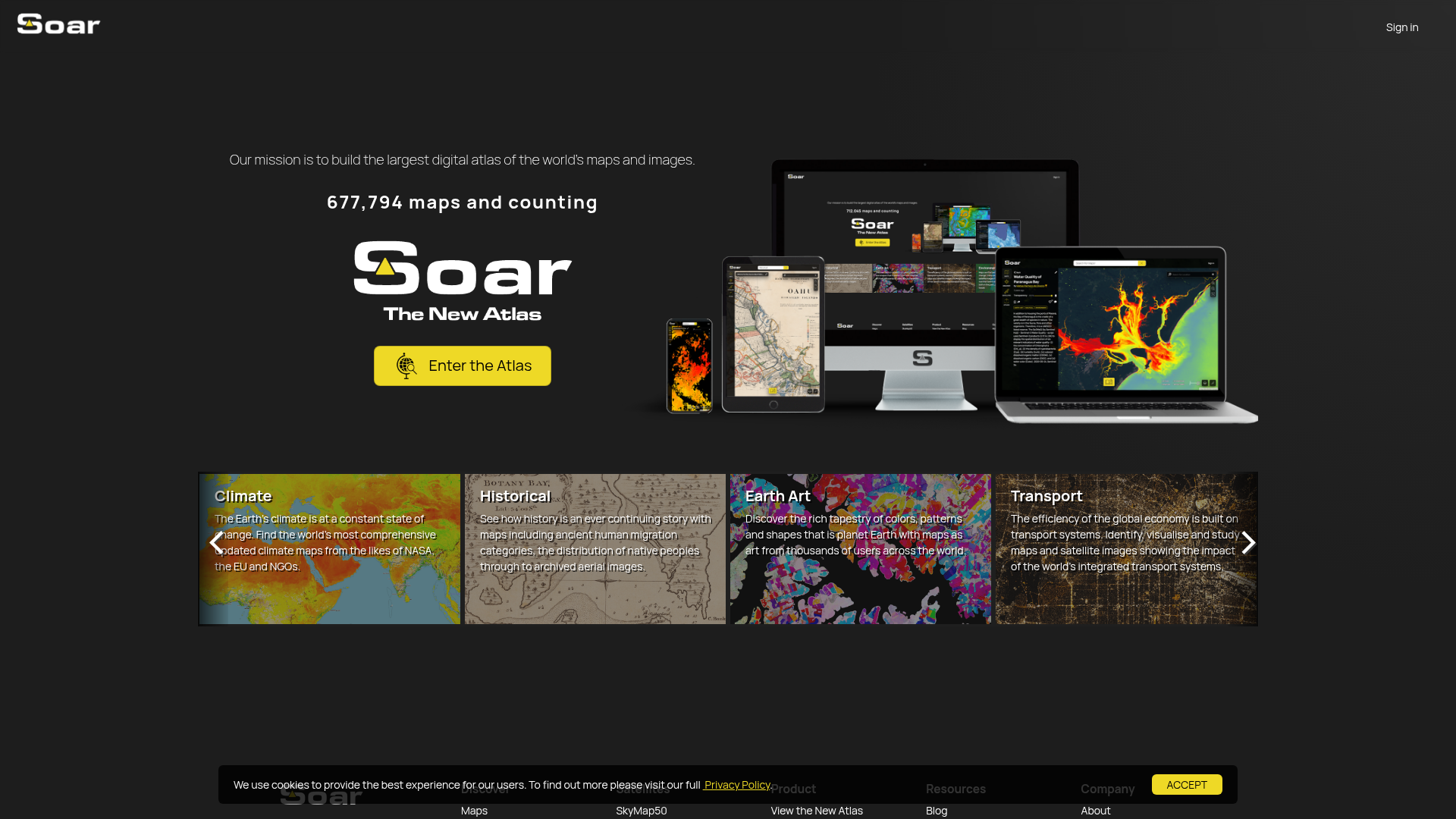
Soar - Explore and share global maps
> "Maps are the language of our planet - and Soar is giving Earth a powerful new voice."

# What is Soar? The Digital Atlas Rewriting How We See Our World

## 🌍 The New Cartographic Frontier

Forget everything you know about static maps. Soar represents a seismic shift in geospatial visualization - a living, breathing digital atlas that aggregates the world's most dynamic mapping data in one revolutionary platform.

I still remember the first time I explored Soar's interface. The depth of layers available - from real-time climate visualizations to century-old urban planning maps - made traditional GIS tools feel like cave paintings in comparison.

## 🔭 Through the Satellite Lens

What sets Soar apart? Three game-changing capabilities:

```mermaid
pie
    title Soar's Core Advantages
    "Real-time Satellite Feeds" : 35
    "User-Generated Content" : 30
    "Academic/Government Data" : 35
- Orbital perspective: Access near-real-time imagery from leading satellite providers
- Crowdsourced intelligence: Thousands of contributors continuously enrich the database
- Institutional partnerships: Direct pipelines to NASA, EU and other authoritative sources
🗺️ Mapping Human Stories
Climate in Motion
Watch climate change unfold through NASA's monthly land surface temperature maps - 1km resolution reveals patterns invisible to conventional tools.
Urban Evolution
Compare historical aerial images with modern satellite views to study how megacities devour landscapes. Soar's time-lapse function tells sobering development stories.
Agricultural Patterns
The platform's agricultural layers reveal something startling - nearly 40% of Earth's ice-free land now shows cultivation patterns when viewed at maximum zoom.
💡 Why Professionals Are Switching
After testing countless mapping solutions, here's what makes Soar indispensable:
- Unprecedented detail: Zoom from continental views to individual city blocks without losing resolution
- Temporal depth: Many datasets include 10+ years of historical records
- Cross-disciplinary: Simultaneously overlay climate, political and economic data layers
🚀 Your World Awaits
Ready to experience next-generation cartography? Here's how to start:
- Visit Soar.Earth (their satellite view will literally take your breath away)
- Explore the Climate section using NASA's datasets
- Create your first custom map overlay (takes <5 minutes)
Pro tip: Bookmark their Historical Imagery portal - it's like having a time machine for geography.
"In an age of information overload, Soar does something remarkable - it makes planetary-scale data feel intimate and actionable." - Geospatial Analyst Review
🌟 The Future of Mapping is Here
While platforms like Google Earth show us where we are, Soar reveals where we're going. Its integration of real-time environmental data with deep historical archives creates something unprecedented - a living atlas that doesn't just display our world, but helps us understand its complex, ever-changing nature.
For researchers, policymakers, or anyone curious about our planet's story, Soar isn't just another mapping tool. It's the closest thing we have to holding the entire Earth in our hands - complete with all its beauty, complexity, and vulnerability.
Features
Climate Maps
Access updated climate maps from NASA, the EU, and NGOs.
Historical Data
Explore ancient human migration and archived aerial images.
Earth Art
Discover artistic maps showcasing Earth's colors and patterns.
Transport Systems
Visualize global transport networks and their impact.
Environmental Changes
Study landscape changes with thousands of satellite images.
Urbanization
Analyze urban growth with maps from governments and organizations.
Agriculture
Track crop yields and farmland variability.
Geology
Access elevation, terrain, and earthquake-prone area maps.
Political Maps
Document conflict zones and ethno-linguistic distributions.
Economic Insights
Study economic maps from leading institutions.
Traffic(2025-04)
Monthly Traffic
Traffic Source
Top Keywords
| Keyword | Traffic | Volume | CPC |
|---|---|---|---|
| soar satellite | 1379 | 330 | 0.83 |
| soar sattelite cam | 1044 | - | |
| soar | 445 | 110470 | 2.24 |
| normandy 1944 map | 419 | 160 | - |
| how have maps changed over time | 267 | 40 | - |
Source Region
Whois
| Domain | www.soar.earth |
| Domain Status | active |
Featured Products
Atlas
Napkin
Eraser
Storydoc
Rosebud
GptExcel
MyMind
Roboflow
Related Categories
Copy embed code
Alternative Products

Preswald


dbits.io-gXkzofjU9C

Atlas

Soar


Baselight

Unify

ScoutAPM